 Home
Home Live Radar
 Live Lockport Sky
 Live Console
 Live Gauges
 Live Scanner Niagara County
 Live Deer Cam
 7 Day Forecast & NWS Charts
 LIVE WNY Weather Conditions
  Almanac
 Station Historical Data & Records
 Marine Info
 Other WX Stations
 Webcams
 Real Time Lightning Map
 24 Hour Rainfall Forecast
 Niagara County Wind Alert
 WNY Satellite
 Niagara County News
 Real Time Weather Twitter
 World Wind Map
 Tornado Report
 Earthquakes
 Flight Tracker
 Closings/Delays
 WNY Snowstorm Total Forecast
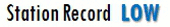


| National Weather Service Severe Weather Alerts / Click County Name For Details |
 |

|
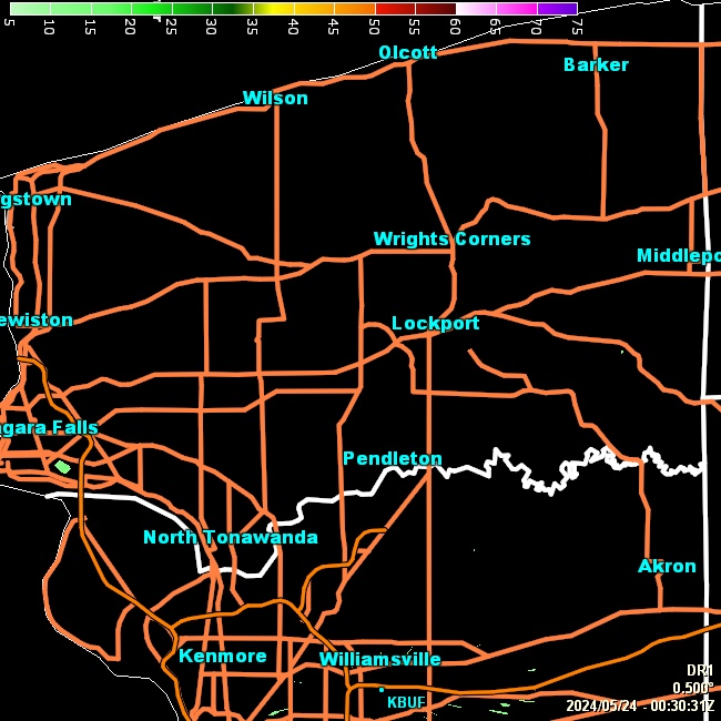
| Click Image For Radar Loop & Storm Details | Click Image For Larger Radar Loop |
WESTERN NEW YORK FORECAST SUMMARY
SYNOPSIS... Lingering clouds and patchy drizzle will clear out from north to south this evening. An expansive area of Canadian high pressure will then assure us of fair, dry weather Thursday through Friday. While some showers will be likely this coming weekend, especially on Saturday, a good amount of dry time will be built in. Looking further down the road, we can look forward to a summer-like warm up Sunday and Monday with the mercury surging well into the 70s and even a few spots into the 80s. |
Todays low temperature of 30.2°F broke the monthly low of 30.6°F set on 04/07/2024 by -0.4°
Todays high barometer of 1024.5 mb broke the monthly high of 1023.0 mb set on 04/07/2024 by 1.5 mb
Todays high barometer of 1024.5 mb broke the monthly high of 1023.0 mb set on 04/07/2024 by 1.5 mb
|
METRIC |
IMPERIAL
|
Weather Conditions Updated: @ 10:15pm | |||||||||||||||||||||||||||||||||||||||||||||||||||||||||||||||||||||||||||||||||
| Temperature | Conditions/Real Time Wind Speed | 36 Hour Forecast/WNY Expected Snowfall | ||||||||||||||||||||||||||||||||||||||||||||||||||||||||||||||||||||||||||||||||
|
|
|
||||||||||||||||||||||||||||||||||||||||||||||||||||||||||||||||||||||||||||||||
| Dew Point | Sun/Moon | |||||||||||||||||||||||||||||||||||||||||||||||||||||||||||||||||||||||||||||||||
|
|
|
|
|||||||||||||||||||||||||||||||||||||||||||||||||||||||||||||||||||||||||||||||
|
|
|||||||||||||||||||||||||||||||||||||||||||||||||||||||||||||||||||||||||||||||||
| Heating Degree Days | Snow3 | Wind Chill | Air | |||||||||||||||||||||||||||||||||||||||||||||||||||||||||||||||||||||||||||||||
|
|
|
|
|||||||||||||||||||||||||||||||||||||||||||||||||||||||||||||||||||||||||||||||
| UV Summary/Forecast | Solar Summary | |||||||||||||||||||||||||||||||||||||||||||||||||||||||||||||||||||||||||||||||||
|
|
|||||||||||||||||||||||||||||||||||||||||||||||||||||||||||||||||||||||||||||||||
| Almanac | Cloud Height | Station All Time Records | Outlook | |||||||||||||||||||||||||||||||||||||||||||||||||||||||||||||||||||||||||||||||
|
|
|
Thursday Sunny |
|||||||||||||||||||||||||||||||||||||||||||||||||||||||||||||||||||||||||||||||


| 1 . 2 Snow season July 1st to June 30th. 3 Snow is manually measured a few times a day as needed 0.01 = a trace . 6 Air Quality Index is provided by Minnesota Polution Control Agency and is updated between the hours of 6AM and Midnight. 10 Historical average only to day 24 of just the month of April for this station since 2010. 11 Historical average rain this season to day 24 of Aprilfor this station since 2010. |
| NWS Weather Forecast - Outlook Tonight & Thursday | ||||||||||||||
|
||||||||||||||
|
||||||||||||||
|
||||||||||||||
|
Version 6.95b - 03-Apr-2019 - Script by: Scott of BurnsvilleWeatherLIVE.com Now supported by Saratoga-weather.org Download |
||||||||||||||


