RSS Mesoscale Discussions from Storm Prediction Center
No Mesoscale Discussions are in effect as of Mon May 6 06:22:01 UTC 2024.
Public Severe Weather Outlook
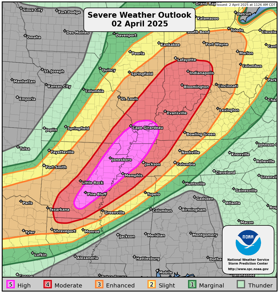
PUBLIC SEVERE WEATHER OUTLOOK CORR 1
NWS STORM PREDICTION CENTER NORMAN OK
0119 AM CDT MON MAY 06 2024
CORRECTED FOR GENERAL AREA
...Severe thunderstorms expected over parts of the southern and
central Plains this afternoon and tonight...
* LOCATIONS...
Western, central and northern Oklahoma
Southern Kansas
* HAZARDS...
Several tornadoes, a few intense
Widespread large hail, some baseball size
Scattered damaging winds, some hurricane force
* SUMMARY...
Numerous severe thunderstorms are expected to develop and move
eastward Monday afternoon through Monday night across parts of
the southern/central Plains. Multiple intense, long-track
tornadoes, very large to giant hail, and severe/damaging winds
all appear likely.
Preparedness actions...
Review your severe weather safety procedures for the possibility
of dangerous weather today. Stay tuned to NOAA Weather Radio,
weather.gov, or other media for watches and warnings. A tornado
watch means that conditions are favorable for tornadoes to form
during the next several hours. If a tornado warning is issued for
your area, move to a place of safety, ideally in a basement or
interior room on the lowest floor of a sturdy building.
&&
Read more
 Home
Home Live Radar
 Live Lockport Sky
 Live Console
 Live Gauges
 Live Scanner Niagara County
 Live Deer Cam
 7 Day Forecast & NWS Charts
 LIVE WNY Weather Conditions
  Almanac
 Station Historical Data & Records
 Marine Info
 Other WX Stations
 Webcams
 Real Time Lightning Map
 24 Hour Rainfall Forecast
 Niagara County Wind Alert
 WNY Satellite
 Niagara County News
 Real Time Weather Twitter
 World Wind Map
 Tornado Report
 Earthquakes
 Flight Tracker
 Closings/Delays
 WNY Snowstorm Total Forecast