 Home
Home Live Radar
 Live Lockport Sky
 Live Console
 Live Gauges
 Live Scanner Niagara County
 Live Deer Cam
 7 Day Forecast & NWS Charts
 LIVE WNY Weather Conditions
  Almanac
 Station Historical Data & Records
 Marine Info
 Other WX Stations
 Webcams
 Real Time Lightning Map
 24 Hour Rainfall Forecast
 Niagara County Wind Alert
 WNY Satellite
 Niagara County News
 Real Time Weather Twitter
 World Wind Map
 Tornado Report
 Earthquakes
 Flight Tracker
 Closings/Delays
 WNY Snowstorm Total Forecast


About This Station
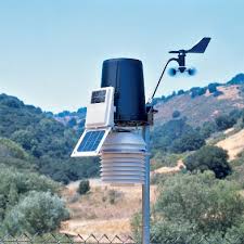
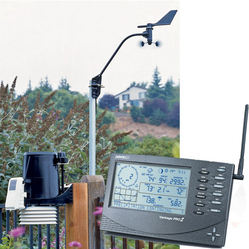
The station is powered by a Davis Vantage Pro 2 Wireless weather station which contains the following Rain collector, Temperature and humidity sensors enclosed in a solar-powered day time fan-aspirated radiation shield (to minimize the effects of radiation) & Anemometer. All situated in optimal positions for highest accuracy possible. The data is collected every 2.5 seconds and the site is updated every 5 seconds This site and its data is collected using Weather Display Software.
About This County
Niagara County is a county located in the U.S. state of New York. As of the 2010 census, the population was 216,469.[1] The county seat is Lockport. The county name is from the Iroquois word Onguiaahra; meaning the strait or thunder of waters.[2] It is the location of Niagara Falls and Fort Niagara, and has many parks and lake shore recreation communities. In the Summer of 2008 Niagara County celebrated its 200th Birthday with the first town of the county, Town of Cambria. Niagara County is part of the BuffaloNiagara Falls Metropolitan Statistical Area. Its Canadian border is the province of Ontario.
Niagara County is in the extreme western part of New York State, just north of Buffalo and adjacent to Lake Ontario on its northern border and the Niagara River and Canada on its western border. The primary geographic feature of the county is Niagara Falls, the riverbed of which has eroded seven miles south over the past 12,000 years since the last Ice Age. The Niagara River and Niagara Falls, are in effect, the drainage ditch for four of the Great Lakes which constitute the largest supply of fresh water in the world. The water flows north from Lake Erie, then through the Niagara River, goes over Niagara Falls, and then on to Lake Ontario and the St. Lawrence River, eventually emptying into the North Atlantic Ocean. Today, tourists and visitors to the Falls see a diminished flow of water over the Falls, since a portion of the flow has been diverted for hydroelectric power purposes. Both the American and Canadian side of the Niagara River have massive electrical power plants. The spectacular Niagara Gorge is the path Niagara Falls has taken over thousands of years as it continues to erode. Niagara Falls started at the Niagara Escarpment which cuts Niagara County in half in an East-West direction. North of the Escarpment lies the Lake Ontario plain, which is a fertile flatland that is used to grow grapes, apples, peaches and other fruits and vegetables.About This Website
This site is a template design by CarterLake.org with PHP conversion by Saratoga-Weather.org.
Special thanks go to Kevin Reed at TNET Weather for his work on the original Carterlake templates, and his design for the common website PHP management.
Special thanks to Mike Challis of Long Beach WA for his wind-rose generator, Theme Switcher and CSS styling help with these templates.
Special thanks go to Ken True of Saratoga-Weather.org for the AJAX conditions display, dashboard and integration of the TNET Weather common PHP site design for this site.
Template is originally based on Designs by Haran.
This template is XHTML 1.0 compliant. Validate the XHTML and CSS of this page.