 Home
Home Live Radar
 Live Lockport Sky
 Live Console
 Live Gauges
 Live Scanner Niagara County
 Live Deer Cam
 7 Day Forecast & NWS Charts
 LIVE WNY Weather Conditions
  Almanac
 Station Historical Data & Records
 Marine Info
 Other WX Stations
 Webcams
 Real Time Lightning Map
 24 Hour Rainfall Forecast
 Niagara County Wind Alert
 WNY Satellite
 Niagara County News
 Real Time Weather Twitter
 World Wind Map
 Tornado Report
 Earthquakes
 Flight Tracker
 Closings/Delays
 WNY Snowstorm Total Forecast


| National Weather Service Severe Weather Alerts / Click County Name For Details |
 |

|
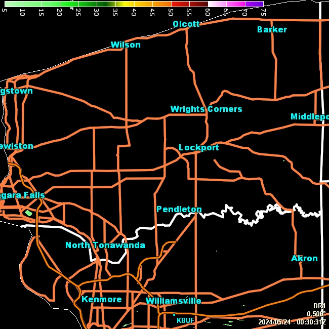
| Click Image For Radar Loop & Storm Details | Click Image For Larger Radar Loop |
WESTERN NEW YORK FORECAST SUMMARY
717 FXUS61 KBUF 021824 AFDBUF Area Forecast Discussion National Weather Service Buffalo NY 224 PM EDT Sun Aug 2 2026 .WHAT HAS CHANGED... Rainfall amounts increased near the Lake Erie shoreline through this evening. Northwest winds increased Monday, most notably southeast of Lake Ontario where gusts up to 28 mph are possible along the lakeshore. |
Todays high wind speed of 13.0 mph broke the monthly high of 11.0 mph set on 08/01/2026 by 2 mph
Todays low barometer of 1004.0 mb broke the monthly low of 1007.6 mb set on 08/01/2026 by -3.6 mb
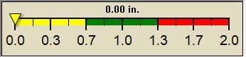
Todays daily rain of 0.63 in broke the monthly high of 0 in set on 08/01/2026 by 0.63 in
Todays low barometer of 1004.0 mb broke the monthly low of 1007.6 mb set on 08/01/2026 by -3.6 mb
Todays daily rain of 0.63 in broke the monthly high of 0 in set on 08/01/2026 by 0.63 in
|
METRIC |
IMPERIAL
|
Weather Conditions Updated: @ 4:29pm | |||||||||||||||||||||||||||||||||||||||||||||||||||||||||||||||||||||||||||||||||
| Temperature | Conditions/Real Time Wind Speed | 36 Hour Forecast/WNY Expected Snowfall | ||||||||||||||||||||||||||||||||||||||||||||||||||||||||||||||||||||||||||||||||
|
|
|
||||||||||||||||||||||||||||||||||||||||||||||||||||||||||||||||||||||||||||||||
| Dew Point | Sun/Moon | |||||||||||||||||||||||||||||||||||||||||||||||||||||||||||||||||||||||||||||||||
|
|
|
|
|||||||||||||||||||||||||||||||||||||||||||||||||||||||||||||||||||||||||||||||
|
|
|||||||||||||||||||||||||||||||||||||||||||||||||||||||||||||||||||||||||||||||||
| Cooling Degree Days | Snow3 | Heat Index | Air | |||||||||||||||||||||||||||||||||||||||||||||||||||||||||||||||||||||||||||||||
|
|
|
|
|||||||||||||||||||||||||||||||||||||||||||||||||||||||||||||||||||||||||||||||
| UV Summary/Forecast | Solar Summary | |||||||||||||||||||||||||||||||||||||||||||||||||||||||||||||||||||||||||||||||||
|
|
|||||||||||||||||||||||||||||||||||||||||||||||||||||||||||||||||||||||||||||||||
| Almanac | Cloud Height | Station All Time Records | Outlook | |||||||||||||||||||||||||||||||||||||||||||||||||||||||||||||||||||||||||||||||
|
|
|
Tonight Showers And T-Storms |
|||||||||||||||||||||||||||||||||||||||||||||||||||||||||||||||||||||||||||||||


| 1 . 2 Snow season July 1st to June 30th. 3 Snow is manually measured a few times a day as needed 0.01 = a trace . 6 Air Quality Index is provided by Minnesota Polution Control Agency and is updated between the hours of 6AM and Midnight. 10 Historical average only to day 2 of just the month of August for this station since 2010. 11 Historical average rain this season to day 2 of Augustfor this station since 2010. |
| NWS Weather Forecast - Outlook This Afternoon & Tonight | ||||||||||||||
|
||||||||||||||
|
||||||||||||||
|
||||||||||||||
|
Version 6.95b - 03-Apr-2019 - Script by: Scott of BurnsvilleWeatherLIVE.com Now supported by Saratoga-weather.org Download |
||||||||||||||


