
 Home
Home Live Radar
 Live Lockport Sky
 Live Console
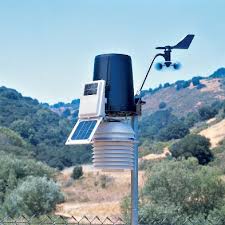
 Live Gauges
 Live Scanner Niagara County
 Live Deer Cam
 7 Day Forecast & NWS Charts
 LIVE WNY Weather Conditions
  Almanac
 Station Historical Data & Records
 Marine Info
 Other WX Stations
 Webcams
 Real Time Lightning Map
 24 Hour Rainfall Forecast
 Niagara County Wind Alert
 WNY Satellite
 Niagara County News
 Real Time Weather Twitter
 World Wind Map
 Tornado Report
 Earthquakes
 Flight Tracker
 Closings/Delays
 WNY Snowstorm Total Forecast


Storm Prediction Center
Notice: Undefined index: DOT in /home/metzeric/public_html/inc-SPCreports.php on line 564
| STORM REPORTS Issued by the Storm Prediction Center |
| Select date for other reports |
June 20, 2026 |
 |
| 32 reports sorted by the latest reports first |
| Jun 20 5:28 pm EDT |
| COLORADO - Yuma COUNTY - 2 MILES EAST-SOUTHEAST OF Laird |
| HAIL - 1.25 in - Along US-34 near CO-NE border. Time estimated from radar. (Goodland, KS) |
| Jun 20 5:22 pm EDT |
| WYOMING - Natrona COUNTY - Natrona |
| WIND - 64 mph - Mesonet station WY45 US20 Natrona (). (RIW) |
| Jun 20 5:21 pm EDT |
| COLORADO - Yuma COUNTY - 1 MILE EAST OF Yuma |
| WIND - 60 mph - Trained spotter estimated 60 mph wind gust. (Goodland, KS) |
| Jun 20 5:17 pm EDT |
| KANSAS - Rawlins COUNTY - 11 MILES NORTHWEST OF Ludell |
| HAIL - 1.50 in - Report from mPING: Ping Pong Ball (1.50 in.). (Goodland, KS) |
| Jun 20 5:17 pm EDT |
| WYOMING - Washakie COUNTY - 11 MILES SOUTH OF Worland |
| WIND - 72 mph - Mesonet station PSDW4 Pistol Draw. (Riverton, WY) |
| Jun 20 5:09 pm EDT |
| NEBRASKA - Hitchcock COUNTY - 4 MILES NORTHWEST OF Stratton |
| TORNADO - According to mping report: A small tornado just touched the ground briefly for a few seconds then lifted and is trying to drop again just west of stratton on road 714. (Goodland, KS) |
| Jun 20 5:09 pm EDT |
| NEBRASKA - Hitchcock COUNTY - 2 MILES NORTH-NORTHWEST OF Stratton |
| HAIL - 2.50 in - mPing Report; time estimated from radar. (Goodland, KS) |
| Jun 20 5:08 pm EDT |
| NEBRASKA - Hitchcock COUNTY - 2 MILES NORTHWEST OF Stratton |
| HAIL - 2.50 in - Report from mPING: Tennis Ball (2.50 in.). (Goodland, KS) |
| Jun 20 5:00 pm EDT |
| NEBRASKA - Hitchcock COUNTY - 5 MILES NORTH OF Stratton |
| HAIL - 1.75 in - Reported from dispatch... time and location estimated from radar. (Goodland, KS) |
| Jun 20 4:59 pm EDT |
| COLORADO - Yuma COUNTY - 4 MILES NORTH OF Wray |
| HAIL - 1.25 in - Spotter network report of half dollar sized hail. (Goodland, KS) |
| Jun 20 4:55 pm EDT |
| COLORADO - Yuma COUNTY - 2 MILES NORTHWEST OF Wray |
| WIND - 58 mph - AWOS station K2V5 2 NW Wray. (Goodland, KS) |
| Jun 20 4:52 pm EDT |
| COLORADO - Washington COUNTY - 7 MILES NORTHWEST OF Woodlin School |
| HAIL - 1.50 in - (Boulder, CO) |
| Jun 20 4:50 pm EDT |
| WYOMING - Fremont COUNTY - 19 MILES EAST-SOUTHEAST OF Riverton |
| WIND - 67 mph - Mesonet station PC633 Poston Ranch Rd (PC). (Riverton, WY) |
| Jun 20 4:35 pm EDT |
| WYOMING - Hot Springs COUNTY - 13 MILES SOUTH OF Thermopolis |
| WIND - 70 mph - AWOS station KTBX Boysen Peak (AWOS). (Riverton, WY) |
| Jun 20 4:29 pm EDT |
| WYOMING - Carbon COUNTY - 2 MILES NORTHEAST OF Rawlins |
| WIND - 61 mph - ASOS station KRWL 1 ENE Rawlins. (Cheyenne, WY) |
| Jun 20 4:25 pm EDT |
| FLORIDA - Lafayette COUNTY - Buckville |
| WIND - Tree down along SW Doe Rd. (Tallahassee, FL) |
| Jun 20 4:20 pm EDT |
| WYOMING - Hot Springs COUNTY - 13 MILES SOUTH OF Thermopolis |
| WIND - 71 mph - Mesonet station PC631 Stagner (PC). (Riverton, WY) |
| Jun 20 4:14 pm EDT |
| WYOMING - Fremont COUNTY - 5 MILES NORTHWEST OF Riverton |
| WIND - 67 mph - ASOS station KRIW Riverton Airport (ASOS). (Riverton, WY) |
| Jun 20 4:00 pm EDT |
| WYOMING - Teton COUNTY - 6 MILES NORTH-NORTHWEST OF Moose |
| WIND - 83 mph - Mesonet station SPPBT Surprise Pinnacle (BTAC). (Riverton, WY) |
| Jun 20 4:00 pm EDT |
| WYOMING - Fremont COUNTY - 3 MILES NORTH-NORTHEAST OF Pavillion |
| WIND - 58 mph - Mesonet station FW3816 Pavillion (CWOP). (Riverton, WY) |
| Jun 20 3:30 pm EDT |
| FLORIDA - Jefferson COUNTY - 2 MILES WEST-NORTHWEST OF Lois |
| WIND - Power lines reported down on W. Washington highway. (Tallahassee, FL) |
| Jun 20 3:20 pm EDT |
| FLORIDA - Jefferson COUNTY - 1 MILE NORTH OF Nash |
| WIND - Multiple trees down across Jefferson County. (Tallahassee, FL) |
| Jun 20 3:12 pm EDT |
| PENNSYLVANIA - Butler COUNTY - 3 MILES SOUTHEAST OF Harrisville |
| WIND - Pole down as a result of tree on wires on Long Rd. (Pittsburgh, PA) |
| Jun 20 2:59 pm EDT |
| PENNSYLVANIA - Mercer COUNTY - 1 MILE EAST-NORTHEAST OF Grove City |
| WIND - Large limb down into power lines on Terrace Ave. (Pittsburgh, PA) |
| Jun 20 2:53 pm EDT |
| WYOMING - Sweetwater COUNTY - 8 MILES SOUTHEAST OF Reliance |
| WIND - 60 mph - ASOS station KRKS Rock Springs Airport (ASOS). (Riverton, WY) |
| Jun 20 2:20 pm EDT |
| WYOMING - Sublette COUNTY - 6 MILES NORTHEAST OF Pinedale |
| WIND - 68 mph - Mesonet station PC258 Half Moon Lake (PC). (Riverton, WY) |
| Jun 20 2:10 pm EDT |
| FLORIDA - Wakulla COUNTY - Crawfordville |
| WIND - Numerous trees and powerlines down across Wakulla County. (Tallahassee, FL) |
| Jun 20 1:51 pm EDT |
| WYOMING - Sublette COUNTY - 8 MILES NORTH-NORTHEAST OF Marbleton |
| TORNADO - Multiple reports... pictures... and videos of a tall (high cloud base)... non-mesocyclone (aka landspout) tornado to the north of Marbleton... WY. No known damage. Loca (Riverton, WY) |
| Jun 20 1:03 pm EDT |
| FLORIDA - Orange COUNTY - 3 MILES SOUTH OF Ocoee |
| WIND - Delayed report. Trained spotter reports large tree blocking Hempel Avenue. Time estimated from radar. (Melbourne, FL) |
| Jun 20 12:18 pm EDT |
| NEBRASKA - Buffalo COUNTY - 4 MILES NORTH-NORTHWEST OF Pleasanton |
| HAIL - 1.00 in - (Hastings, NE) |
| Jun 20 11:58 am EDT |
| TEXAS - Calhoun COUNTY - 7 MILES NORTH OF Tivoli |
| TORNADO - Multiple sources such as broadcast media... public... law enforcement... and emergency management have reported pictures and videos of a once tropical funnel cloud touc (Corpus Christi, TX) |
| Jun 20 10:50 am EDT |
| NEBRASKA - Buffalo COUNTY - 6 MILES NORTH OF Riverdale |
| HAIL - 1.00 in - (Hastings, NE) |
|
Daily reports from the Storm Prediction Center starts at noon UTC and ends at one minute before noon UTC the next day. This time period is between 8am EDT and one minute before 8am EDT the next day.
All reports are considered preliminary and should be treated as such. |